The map featured above is from a Chinese book, “A Short History of Modern China” published in 1954. The area within the bold line is claimed as Chinese territory. The legend at the bottom left of the map says:- – Borders at the time of the Opium War of 1840, and -:-. Borders on the conclusion of the Era of the old democratic revolution of 1919. The Chinese text in little rectangles is translated (below the map) according to the number.
- The Great North-West, according to the Chinese text in the map, ” was seized by Imperialist Russia under the Treaty of Chuguchak, 1864.” It covers segments of the Soviet Republics of Kazakhstan, Kirghizia and Tajikistan.
- The Pamirs were “secretly divided between Britain and Russia in 1896”.
- Nepal ” went under the British after ‘Independence’ in 1898.
- Che-Meng-Hsiung (present-day Sikkim) was “occupied by Britain in 1889”.
- Pu-tan ( the whore of Bhutan) ” went under Britain after ‘Independence’ in 1865″.
- Ah-sa-mi (Assam, which then included Arunachal Pradesh) was “given to Britain by Burma in 1826”.
- Burma ” became a part of the British Empire in 1886″.
- The Aupaman Islands (Andaman) “went under Britain”.
- Ma-la-chia (the whole of present-day Malaya) was “occupied by Britain in 1895”.
- Hsien-Lo (the whole of Thailand) was “declared ‘Independent’ under joint Anglo-French control in 1904”.
- Annam (the present-day North and South Vietnam, Laos, Cambodia) was “occupied by the French in 1895”.
- Taiwan and P’enghu Islands were “relinquished to Japan following the Treaty of Shimonoseki, 1895″.
- Su-Lu Islands was “occupied by the British”.
- The region where the British crossed the border and committed aggression.
- Liu-Ch’iu (Ryukyu Island) was ” occupied by Japan in 1910″.
- and 18. The Great North-East covering a huge area of the Soviet Far East, “was given to Russia under the Treaties of Aigun (1858) and Peking (1860). “
- K’u-Ye (Kurile Island) was ” divided between Japan and Russia”.
My Comment:
The featured map at the top was disseminated abroad in the 50s by China’s diplomatic Missions. The Chinese Embassy in New Delhi had it printed in India for distribution locally and in other South and South-East Asian countries. (I came across it in the 80s courtesy of the now-defunct Mehta Publishers.)
The Indian official public reaction to this map at the time is unknown. One thing is clear, though: India did not question the Chinese territorial claims specified in the map during Zhou En-Lai’s 1954 visit to India – when the Sino-Indian Panchsheel Agreement was signed – or during Nehru’s meetings with Mao and Zhou in Beijing in November that year. (Records of those meetings are revealing even today in the 2022 Sino-geopolitical context.)
The 1954 map effectively represents something of a composite of Chinese territorial claims, both seawards (“blue soil”) – the dash-dash configuration – and landwards – the dot-dash configuration. I understand that the book “A Short History of Modern China” still forms part of academic references at ‘junior’ educational centres in China.
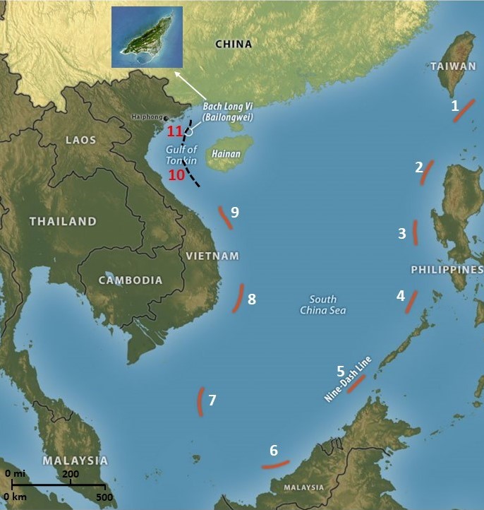
Today, China’s 9DashLine map dominates the discourse on its claims in the South China Sea. But initially, it was an 11DashLine until Mao ceded claims in the Gulf of Tonkin to Vietnam to help it battle the Americans (above).
The most notable difference between the 9DashLine and the 1954 version is that Chinese territorial claims in the Bay of Bengal (and in the Sulu Sea, and Malaysia) are not specified. While these claims have been reiterated by ‘unofficial’ Chinese sources now and then over the past three decades, no official documentation has publicly emerged to buttress them. In any case, it is all academic. China is now assiduously involved in a strategic competition with India in the Bay. It is invoking its claims indirectly in the form of its forays under the banner of the Maritime Silk Road, multiplying PLAN presence in the Bay along with military cooperation with bordering regional nations – Bangladesh, Myanmar and Sri Lanka.
Is the 1954 map relevant at all in 2022? Professional sinologists would have their views. I offer only one observation.
In pre-imperial China, when a defeated kingdom conceded territory to the victorious state, the deal was sealed by surrendering the map of that territory. During the times of earlier imperial Chinese rulers, it became the practice to possess collections of objects symbolic of cosmological significance. These gradually evolved into formal art collections, which invariably included, among other objects, maps, calligraphy, paintings and epigraphy on bronzes. These extensions of calligraphy represented the supreme written word. They told the story of the dynasty. While aestheticism was no doubt an aspect of these collections, the vital motive was to symbolise the possession of political legitimacy of the reigning Emperor.
Interestingly, fleeing China in 1949, Chiang Kei-Shek devoted much time and effort to evacuating former imperial collections to Taiwan; his prime intention was to underline the claim that he was still the legitimate ruler of China. The new communist rulers viewed this as a sore setback for their political authority. They immediately began building their own ‘imperial’ counter-collection (inviting private collections, outright confiscations and instituting a program to buy objects at considerable costs in Europe and Asia).
In short, Chinese maps, whatever their vintage, are the final written word as far as China is concerned, and provide legitimacy to its territorial claims. They can not be ignored.
As a postscript, it is notable that in the seven decades of Sino-Indian negotiations on their border dispute, China has never quite laid down in black or white where it believes the border should be in some lengths of it. While the Line of Actual Control established after its 1962 victory signifies a clear enough point of reference for demarcation in some sectors, the Chinese continue to present a moveable feast of changing claims over chunks of Indian territory. Clearly, it is in its interest that an unsettled border will keep India occupied with immediate local imperatives and prevent it from projecting its broader power. But it may be more than that: Is it because the Chinese’ own historical maps do not entirely support their old/traditional claims? To my knowledge, the Indians have not researched the imperial collections in Taipeh. Perhaps they should